Yesterday I made my first solo foray into Denver. The temperature was in the mid-seventies and I wanted to give my 60 mm macro lens (35 mm equivalent = 120 mm) a thorough workout, so I headed to the zoo. First up: some sea lions who were having a serious disagreement.
Colorado
Georgetown window no. 3 ~
This is my favorite of the window photographs I took in Georgetown last Saturday. iPhone photo, cropped.
Georgetown window no. 2 ~

Georgetown window no. 2
Didn’t notice until just now that there’s someone’s head in this photo. I think I’m going to take care of that when I’m less tired. Georgetown was crowded late Saturday afternoon, probably with other folks who had headed out to see the aspens.
Georgetown window no. 1 ~

Georgetown window no. 1
Getting away from travel-related posts here for awhile and back toward art photography.
A peek at South Park ~
For yesterday’s drive I skirted Denver on the west side and took U.S. Hwy. 285 over to Kenosha Pass and down to South Park. I’d been keen to see this part of Colorado ever since I read a magazine writer’s comment that, though he’d been many places in the world, the view down across South Park from the pass was his favorite. Not ever having watched the animated series “South Park,” I didn’t know that it was named after a real place. (There is also a North Park, northwest of Rocky Mountain National Park.) The designation “park” here refers to a broad plateau or basin ringed by mountains.
I stopped to eat lunch at Fairplay, then took state route 9 up through Alma (10,578 feet elev.), and over Hoosier Pass (as it turns out, there are two Hoosier Passes in Colorado, both of them—I presume—originally sited in Indiana, then trucked west and greatly enlarged). A series of hairpin turns on the other side of the pass takes you down to Breckinridge. There were still golden-leafed aspens along 285 east of Kenosha Pass and in Breckinridge; elsewhere, the aspens were mostly bare. Given the abundance of stands on the slopes, it must have looked spectacular a couple of weeks ago. Now I know an ideal driving route for seeing the fall colors in Colorado.
A patch of prairie ~
These photos were taken at the Cathy Fromme Prairie Natural Area, just south of Fort Collins, Colo. This acreage, which has never been plowed, is bounded by two major roads to the east and west and by housing developments to the east and north. It’s lovely country, but the traffic noise is omnipresent. When I had walked about 15 minutes, it began thundering persistently, so I backtracked to the parking area. I didn’t get photos of the many flowers still in bloom, many of them very small and easy to overlook.
Where there are no roads ~

Never Summer Wilderness
View west from Trail Ridge Road to the Never Summer Wilderness.
Aspens ~
Yesterday I took my sister for a 7-hour drive to see the aspens in their fall colors. We drove from Loveland to Boulder, up Boulder Canyon, down the Peak-to-Peak Highway, up Hwy. 40 to Granby, up Hwy. 34 to Rocky Mountain National Park, and across Trail Ridge Road. We didn’t stop for photos very often, but here are a few.
Bugle boy ~
I’ve finally heard an elk bugle, and it’s an impressive sound. This fellow in the Beaver Meadows section of Rocky Mountain National Park had a harem of five females and a youngster. Just before I took this photo, he bugled out a couple of announcements to other males that might be in the vicinity: Here I am, and I’m better than you are. Herds of elk also could be seen above the treeline across a great valley from the Alpine Visitors Center; from that distance they looked like dozens of little brown rocks, just dots on the landscape. Before long they’ll be thronging the streets of Estes Park.
No guardrails ~
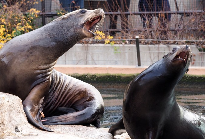
Today I drove Old Fall River Road up to the Alpine Visitors Center in Rocky Mountain National Park. This route was the first road through the park. Today it’s one-way (uphill) and nine miles of it are dirt. Very little of it runs above the tree line, so it affords very different views than you find from Trail Ridge Road.
At the Visitors Center one can climb “Huffers Hill,” which rises a bit over 200 feet in elevation, taking you to 12,005 feet. I didn’t think I could get up there, but with a lot of rests, I did, and a kind young woman offered to take my photo at the elevation sign. Normally I don’t include myself in photographs, but I was happy and proud that I’d made this climb—such a little thing to most people, but a big thing for me—so it seemed okay to make an exception. It was 46 degrees and very windy. Gloves would have been a good idea; also a scarf and a more suitable hat.
On the way up I was passed by a talkative group of Japanese tourists. When I reached the top, they were taking pictures with their phones. I walked on to the sign at the end of the trail. When I turned back, I saw that they had all sat down, some on the ground and some on a rock outcrop—silent, eyes closed. They were meditating. Their silence was of a piece with the silence of the stones. Only the wind could be heard. Theirs seemed the most apropros response to the landscape, and I considered sitting with them, but I was afraid if I sat down I wouldn’t be able to get up again. The coldness of my ears also argued against any possibility of meditating, so I walked back down (much harder on the legs than the walk up, but a nice respite for lungs and heart).