The University of Wyoming (Laramie) Art Museum is fairly small but had a few works of interest when I visited there last summer. The most stunning by far was an installation of dozens of 24″ x 96″ aluminum panels hung like sails and banners in the atrium. This massive piece, by New York–based artist Sharon Louden, is called, appropriately, “Windows.” The photograph above shows portions of two of the panels. I’ll have more photos, but I thought each deserved its own post instead of being grouped; there’s so much going on in any one view. The installation was designed especially for this space and thus, I hope (please please please), will stay permanently.
Road Trips
A day at Pawnee Buttes ~
Last week a friend and I drove out to Pawnee Buttes, in the Pawnee National Grassland. This is on the prairie in northeast Colorado, not far south of Wyoming and Nebraska. It was a warm but lovely day. The grassland is beautiful: lots of miles on dirt roads; beautiful undulating hills; and the isolated buttes themselves. The only downside is the sheer number of oil and gas facilities out here, along with the accompanying truck traffic. In a time when it’s imperative that we phase out fossil fuels, I was discouraged to see the amount of fracking and other fossil-fuel extraction on this, one of our national treasures.
Fog, frozen, fleeting ~

Frozen fog coating trees along I-25

A view to the northeast
We’ve had freezing fog the past couple of nights. Here’s what it looked like on the trees and plains bordering the interstate north of Fort Collins, not too far south of the Wyoming border. The sky wasn’t really sunny, and all of the colors were muted. Interstate exits are infrequent on I-25 between north Fort Collins and Cheyenne, and the one that would have worked looked to be blocked by an accident, so I finally pulled off onto the shoulder and shot through the side windows and windshield. Don’t like to do that for photographs, but this was too beautiful to pass up.

Heading north on I-25
Sacajawea’s sunset ~

Sacajawea cemetery, Fort Washakie, Wyoming

Sacajawea grave marker

Pronghorn antelope, Fort Washakie, Wyoming

Sunset south of Cheyenne
My drive back to Loveland from the Tetons took me through the Wind River Indian Reservation, where I saw a highway sign that said “Sacajawea’s Gravesite.” After a failed attempt to locate it, I got directions at a roadside shop, which took me to a small but colorful cemetery next to a field where a herd of pronghorn antelope were grazing. Some of the markers in the cemetery were brightly painted wood crosses; others were more-conventional stone. But all of the graves were dotted with artificial flowers and little knick-knacks. I don’t know if this is typical of present-day American Indian cemeteries. I also wondered if there might be a Latino influence here. Whatever the answer, it makes standard American cemeteries look pretty, well, dead in comparison.
But I digress. Sacajawea’s marker was about halfway up the slope. People had left all sorts of little offerings at the base. The infant, Jean-Baptiste Charbonneau, that she carried on the Lewis and Clark expedition has a marker next to hers. It seemed remarkable to me that my route home so unexpectedly took me within a mile of Sacajawea’s gravesite. It also seemed like a scandal that there were no signs, once you were off the highway, to point the way to this lonely, windswept cemetery. I paid my respects, wishing that I had some little thing to leave that would be appropriate.
Then, after I got home, I discovered that I might not have been paying homage to Sacajawea at all in that desolate place. There is, in fact, quite a controversy about Sacajawea’s death. Some documentary evidence that does not quite rise to the level of proof indicates that she died in 1812, in South Dakota. The cemetery marker I saw underscores an alternate hypothesis, also generally considered unproven: that Sacajawea survived, lived with the Comanches for some time, and eventually returned to her people, the Shoshone, on the Wind River reservation, where she died in 1884, around the age of 100.
Some websites mention the controversy; others simply state one or the other hypothesis as the truth. The only thing that can be said with certainty is that we’ll never know the truth about Sacajawea’s death.
So my trip ended with a mystery. It seemed fitting that this day also ended with a staggeringly dramatic sunset, which I photographed by pointing my camera toward the passenger-side window as I raced along with the traffic on I-25. It was past dusk. I didn’t dare try to pull off on the shoulder, and there was no exit handy. I just hoped that somehow the camera would focus well enough for one semi-sharp photograph. And it did.
In hot water one more day ~

This too is Yellowstone

Buffalo herd by the Madison River

Through the windshield
My second full day in Yellowstone started with a traffic jam. After half an hour of inching along the road, I finally saw the reason for the hold-up: A entire herd of buffaloes was moving east between the road and the Madison River. Some of the buffaloes had found a nice place to roll cumbrously in the dust. Two males decided to spar. And I spotted a still-reddish baby buffalo in the group. If I’d been sitting in the passenger seat I could have reached out and touched some of these animals. As it was, for many of the photos I took I had to hold the camera up high to keep buffalo heads from being obscured by the door frame. And so, like everyone else on the road, I contributed to the traffic jam.
After the buffalo jam I hoped to visit a favorite of mine, Grand Prismatic Spring, but I gave up—cars spilled over from the parking lot all the way to the main road and more. Instead I spent an hour or so on Firehole Lake Drive, where there were few people but several interesting geysers and pools.
In the meadow between the geyser area and Firehole Lake, I stopped by this small stream and dipped my hand into the water. The morning was in the 40s, but the water was quite warm from the geyser runoff.

Stream, Firehole Lake Drive
Eventually I drove south to West Thumb Geyser Basin, on the edge of Yellowstone Lake. From here you can see hot springs, geysers, the lake, and the distant mountains all in the same view. It was tough to get people-free shots here, because the boardwalks were crowded with selfie-taking tourists—a people jam. But it was worth the jostling to see the lake and the brilliant colors of the two pools below, the most beautiful at West Thumb.
I walked twice as far as I expected to at West Thumb. As I was heading back to the car from the lake, a ranger closed the boardwalk ahead of me because a group of elk were getting too close to the crowds, or vice versa. I backtracked along the lake all the way around to the other side of the basin—where people also were, you guessed it, being turned back toward the lake because of a large bull elk. So I backtracked over my backtrack and found a middle route up the slope.
At this point my feet were aching and I was extremely glad that I’d packed cheese and crackers and grapes in the car. Despite the crowds, some of the restaurants in Yellowstone had already closed for the season. After my early picnic supper, I drove down to Teton National Park, where the blinding sun just before sunset rendered the mountains extremely hazy. The photo below, considerably tinkered with in Photoshop, was the best I could do, which is not saying much. After getting lost a bit, I discovered that my motel for the evening—actually a cabin at the Togwotee Mountain Lodge—was about 15 miles east. And so I ended up not really seeing the Tetons on this trip. After several sleepless nights and lots of walking, I knew I needed to head home the next day.

Tetons at sunset
But in the morning, before continuing east, I drove back about five miles west for a last glimpse of the mountains. And a wonderful visual effect occurred: As I rounded a curve, a mountain came into view on the horizon. Then another one, taller. Then another one, still taller. As the road continued curving, to my astonishment yet another mountain, massively tall, appeared. The Tetons are familiar to most Americans from countless movies and photographs. I’ve seen them on a couple of previous trips. Yet, like the Grand Canyon, they surprise you every time in person. I hope to go back.

Distant view of Tetons
Full-on Yellowstone ~
When you’ve been away from a beautiful landscape, your memory loses some of the particulars of its beauty and changes others. That’s what I was thinking when I drove through the Lamar Valley (see last post). If Yellowstone had no geysers, no hot springs or mud pots or fumaroles—even if it had no elk and bison—it would still be a stunningly glorious place.
This day, however, I experienced another stunning aspect of Yellowstone: the sheer numbers of people. I knew it would be crowded, but I was astonished by just how crowded in was even in late September. The crowds included all sorts of people but were dominated by Japanese and, I think, Korean couples taking selfies at every pool, every geyser, every sign. Yet still I had a few moments by myself at Mammoth Hot Springs and at Porcelain Basin, part of the Norris Geyser Basin, literally the hottest spot in the park, with springs almost as hot as boiling, and highly acidic to boot.

Palette Spring, Lower Terrace, Mammoth Hot Springs

Dryad Spring, Upper Terrace, Mammoth Hot Springs

Dead tree and dead spring, Upper Terrace, Mammoth Hot Springs
The oranges and reds in these photos are created by communities of thermophiles (heat-loving bacteria); the greens are created by communities of cyanobacteria (also thermophiles, but a very different kind, commonly called blue-green algae). When the source of a spring changes and the spring dries up, these organisms die, and only the chalky whiteness of the travertine formations remains.
Porcelain Basin is my favorite place in Yellowstone because of the lovely colors, many of them pastel but some brilliantly vivid. The features here include not only hot springs and geysers but fumaroles—essentially, steam vents. A light spray from these vents misted my skin and hair as I walked down into the basin.

Fumaroles, Porcelain Basin

Hot springs, Porcelain Basin. The teal-blue comes, in part, from arsenic.

Cyanobacteria (blue-green algae) in runoff from a hot spring

One overview, Porcelain Basin
After Porcelain Basin, I drove through the Madison River valley to West Yellowstone to secure a hotel room for the night, then got to Old Faithful at dusk. I’ve seen this geyser on several previous trips, but never saw so many people waiting for it to erupt. It was fortunate that I wasn’t anxious to get a good photo of Old Faithful, because it was almost dark and both of the batteries for my Olympus were exhausted. At the moment the geyser started to erupt, hundreds of cell phones were lifted up simultaneously by the people in attendance. To an alien it would have resembled some bizarre worship ritual. Here’s one of my obligatory iPhone photos—color noise and all—to cap off this day.

Old Faithful at dusk
Back to Wyoming: On the Beartooth Scenic Byway ~

Looking west over the Beartooth-Absaroka Mountains from Rock Vista Point

Tree against bare mountain slope
Picking my road trip back up where I left off: On Day 3 I took the Beartooth Scenic Byway from just southwest of Red Lodge, Montana, to Yellowstone. I’d heard how beautiful this route is, and even though the day was foggy, rainy, and finally snowy, what I’d heard was true. This is, according to Wikipedia, the highest-elevation road in Montana or Wyoming, and somewhere recently I read that the rocks exposed at Beartooth Pass (elevation 10,947 feet) are Pre-Cambrian, making them some of the oldest exposed anywhere in the lower 48 states. The drive is through glaciated terrain. Near the top of the pass is a large plateau with many small alpine lakes. It started snowing as I drove across the plateau, and at the pass itself the view was totally obscured. The wind was up and the temperature was down to 28 degrees, so I didn’t venture out of the car.

Plateau east of Beartooth Pass

Snow at Beartooth Pass
The weather gradually cleared as I descended the west side of the pass. Aspens, a waterfall, and distant peaks made this a beautiful drive. The highway, which begins in Montana and then dips down through Wyoming, curves back up to Montana and the small mountain town of Cooke City, where it was snowing. Heading out from Cooke City, you come to the northeast entrance of Yellowstone National Park.

Aspens west of Beartooth Pass

Waterfall west of Beartooth Pass

Lake west of Beartooth Pass

Pilot Peak
Almost as soon as I entered Yellowstone, I spotted two bison near the road. I was delighted. Well, little did I know that two bison were nothing compared to what was coming: whole herds! Buffaloes on the road, even. Buffaloes spread all across the Lamar Valley, where the snow had stopped, the sun had come out, and the meadows looked golden.

Buffalo closeup

Looking east from the Lamar Valley toward the Beartooth Mountains

Braided river in the Lamar Valley

Cloud view to the southwest
As I got close to Mammoth Hot Springs, I could see steam rising from the far-off terraces. In town, elk were hanging out on the grounds of the local clinic. A couple of weeks earlier, a tourist had drawn the ire of a bull elk here and narrowly escaped injury. I parked at the clinic for a few minutes, where this bull elk was bugling and keeping his little harem pointed in the direction he felt was suitable. The sign in the clinic window, which I didn’t notice until I was looking at these photos, reads: “Elk present?!?! Use back door.” This elk certainly looked and sounded like he didn’t want to be trifled with, and I took this photo through the windshield. Tomorrow: Hot springs and geysers!

Bull elk, Mammoth Hot Springs
Warped blinds ~

Warped blinds
Taken at an abandoned gas station in Powder River, Wyoming.
Not just dinosaurs ~

Hypacrosaurus, a duckbill dinosaur of the late Cretaceous
The second day of my trip I also went to the Wyoming Dinosaur Center, in Thermopolis. Unfortunately, I was so sleep-deprived that I couldn’t do it justice, which was a shame. This is a fantastic museum house in what is essentially an enormous pole barn. Why is something like this in Thermopolis? Because dinosaurs are being excavated here! The center raises donations to support its excavation work on a nearby ranch, as well as its preparation work, which museum visitors can observe through viewing windows. They’re planning for a beautiful new facility where they can better house their fossils and fossil replicas, and they have lots of both. Visitors also can pay to assist at the dig site, which in turn supports the scientific work.
Not just dinosaurs are on display; the museum is organized to show the progression of evolution from early organisms through the age of the dinosaurs, birds, and early mammals. I found myself wishing I had the time to read every single interpretive sign. Most of these iPhone photographs are of actual fossils, not replicas.

Fossil brittle stars – Wyoming Dinosaur Center

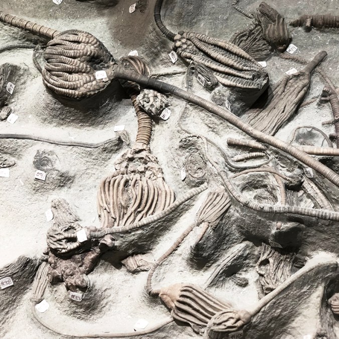
Fossil crinoids (sea lilies) – Wyoming Dinosaur Center
An especially prized fossil here is this one from China, of Microraptor, a small dinosaur with feathers not just on its arms but also its legs. You can see the impression of the feathers on all four limbs and also at the end of the tail.

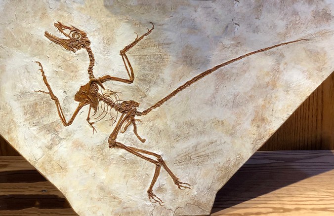
Microraptor, a small dinosaur with feathers on all four limbs – Wyoming Dinosaur Center
The museum has plenty of large, complete dinosaur skeletons. Among the smaller dinosaur fossils is this beautiful specimen of Stenopterygius, a Jurassic-age ichthyosaur. But not just any old Stenopterygius. To quote the interpretive sign: “Ichthyosaurs are vivaparous, meaning they give birth to live young instead of laying eggs. The baby would come out tail-first to prevent them from drowning. This specimen preserves a mother in the act of giving birth.” Wow! And indeed, in the second photo below you can see the baby’s skeleton dangling below the mother. I’ve also included a shot of just the head and upper body because it is so gorgeous.

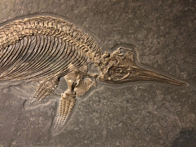
A female stenopterygius…

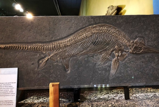
…in the process of giving birth! – Wyoming Dinosaur Center
Another surprise: Fossilized dinosaur embryos and a reproduction of a nest of baby dinosaurs.

Fossilized dinosaur embryo – Wyoming Dinosaur Center
From tiny to enormous: Kids will love the big dinosaur skeletons.

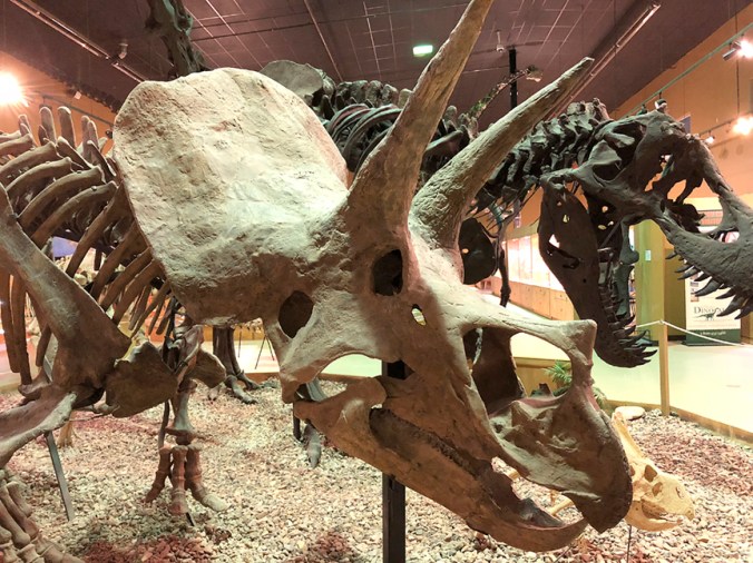
This Triceratops horridus skeleton is the actual fossil, not a replica – Wyoming Dinosaur Center
-
This head belongs to a complete replica Pliosaur skeleton – Wyoming Dinosaur Center
I’ve been in a lot of natural history museums, so it’s possible I’m just forgetting, but to my knowledge I’d never seen a fossilized mortichnial trackway before. It’s the track or footprints of a dying animal—in this case, the final 32 feet of life of a horseshoe crab, which extended across nine large excavated panels on display. This particular exhibit, more than any other at the center, really brings it home to you that all these animals once were as alive as you are now.

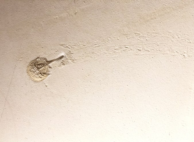
Fossil horseshoe crab and last segment of mortichnial trackway – Wyoming Dinosaur Center
I’m no paleontologist, but I can hardly say enough good things about the Wyoming Dinosaur Center. It’s only a six-hour drive from Loveland, not counting stops, and I’d gladly make a special trip just to visit here again. I didn’t notice any “No photography” signs, so I’ve taken the liberty of posting all of these photos as a kind of advertisement for the center. Long may it live!

Whiptail stingray – Wyoming Dinosaur Center. I don’t know what exactly all those filaments are, but the beauty of this 50-million-year-old fossil blew me away.
Hot Springs State Park ~

Hot Springs State Park, Wyoming
I spent part of Sunday at Hot Springs State Park in Thermopolis, Wyoming. This site is billed as having “The World’s Largest Mineral Hot Spring” (see photograph). The springs, which feed three bathhouses/pools in the park, were acquired from the Shoshone and Arapaho in a 1896 treaty with the stipulation that they be maintained free of charge for everyone. So far, that stipulation has been honored. I didn’t have time to visit any of the bathhouses—and hadn’t brought a swimming suit, not having read up on Thermopolis before I left Loveland. But that was okay; the previous day’s drive had been hot in advance of a front (87 degrees west of Casper in late September!), and I was relishing the refreshing coolness on Sunday. I was also relishing the lack of crowds while I had the chance; things would be very different at Yellowstone.
The park has several places to see the travertine formations created by runoff from the springs. The travertine is deeply “stained” by heat-loving bacteria, making a colorful sight. One of the most interesting things about the hot springs area is the profuse growth of cyanobacteria (blue-green algae) in the runoff. These bacteria form long, thick mats that ripple in the current like hair. The water where they grow is about 110 degrees Fahrenheit. Reddish and orange bacterial mats predominate where the water is warmer.

Streamers of cyanobacteria live in the runoff channels at Hot Springs State Park

Heat-loving bacteria are responsible for the red, orange, and yellow colors

A mix of bacteria (reddish-orange) and cyanobacteria (green)
The park is on the Bighorn River, which is actually the downstream reaches of the Wind River. The dual names resulted from the fact that, until Wind River Canyon was discovered, no one realized that the Wind River cuts north through the Owl Creek Mountains. Just south of Thermopolis, it becomes the Bighorn. The original Crow (Apsáalooke) word for the Bighorn is a whopper: lisaxpúatahcheeaashisee, “which translates to English as Large Bighorn Sheep River” (thanks, Wikipedia).

Bighorn River north of Thermopolis
Besides the hot springs, the park also features a suspension bridge over the Bighorn River and a drive through a hilly range that’s home to a buffalo herd. The red sandstone hills surrounding Thermopolis date back to the early Triassic and are called the Red Peak Formation (part of the larger Chugwater Formation). According to a park sign, the nearly 600-foot-thick formation is almost devoid of fossils because one of the planet’s great extinction events had taken place at the beginning of the Triassic.

Hot Springs State Park, Wyoming. The green in the water is long mats of blue-green algae (cyanobacteria), which thrive in the warm water.

On the (fenced) range at Hot Springs State Park, Wyoming

Part of the bison herd at Hot Springs State Park, Wyoming
I spoke to a man who was using a decoy dummy to train two 8-week-old pups to retrieve ducks. They were splashing in a little inlet of the Bighorn River where there was runoff from a large hot spring. The water temperature at that location stays in the 70s year-round, he said. The pups were having a blast but were more interested in playing and checking out visitors than retrieving the dummy. They were joyful, muddy, and very, very wet.

Pups being trained to retrieve ducks
Next up: A visit to the Wyoming Dinosaur Center.