
A final, four-part love letter to the rock walls of Canyon Country.
A final, four-part love letter to the rock walls of Canyon Country.


The north section of Arches National Park, which has the most trails, was closed for road repairs and construction when we visited, and another popular section was so crowded that no parking spots were available. My companion and I found ourselves both suffering from a world-too-much-with-us malaise. (See here my post A plea for public lands, or better yet, read Desert Solitaire by the very prescient Edward Abbey.) We ended up just getting out at a couple of overlooks and then walking a very short trail to Sand Dune Arch. That arch isn’t pictured here: I left my camera in the car because of the strong, gusty wind; sand grains stung the skin and tourists without sunglasses were shielding their eyes. Sand Dune Arch is sandwiched between tall fins of rock that form a little slot canyon, the bottom of which is piled deep with sand of a uniformly red color (due to its iron content). Burrowing my hand into it, I discovered that it was the finest-grained sand I’ve ever felt, almost velvety, perhaps because it is eroded from rock only rather than being a mixture of rock and marine shell.
So the only arch in my photographs was taken, ironically, at Canyonlands. At the north end of this park, a paved road travels south along a skinny mesa appropriately called Island in the Sky. The mesa is a long finger pointing down into the heart of the labyrinthine canyon systems that make up the bulk of the park, hundreds of feet below and extending for miles east, south, and west. Mesa Arch, which is pictured here, stands on the eastern edge of Island in the Sky midway between the visitors center and the end of the road, Grand View Point. By the time we got there, the sun was at the horizon.


In tiling these photos, WordPress has made the big small and the small big. It’s fitting. This landscape is so vast that gigantic land formations, even mountains, are small on the horizon when seen from distances of 20, 50, 100 miles. And only when you take the time to pay attention close at hand do you realize how many plant species are blooming all around you, dwarfed by the rock.
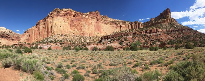
My blog is sagging under the weight of so much rock. For today, I’m posting just one Utah photograph, taken at Capitol Reef National Park. (It’s an iPhone panorama—I hadn’t experimented with this feature until now.) Aside from the highway that cuts across the north end of Capitol Reef, the park has only one paved road, which travels south just a few miles. At its terminus (shown here), a dirt road will take you about two miles east, through a narrow canyon called Capitol Gorge.
That road also leads me to a political note. The first time I visited Capitol Reef was in 1991. That visit was in May, before the full-fledged summer tourist season. My then-husband and I had the place to ourselves. We drove on a dirt road—probably Capitol Gorge Road—that was so rough I worried our little compact car would be shaken to pieces or get hung up on a rock and we’d be stranded for hours or days. Our vehicle was the only one on that curvy road, and we felt isolated indeed winding among the towering cliffs bordered by trees. It was beautiful, and it felt very remote.
This time around, at the same time in May, Capitol Reef was jammed with cars. The dirt road, it seemed, had been improved—still a little rough, but nothing like what I remembered; still beautiful, but heavily traveled.
The Trump Administration wants to declassify a number of national monuments, many of them long-established ones and a number of them in southern Utah, to open them to oil and gas drilling. This, I believe, would be a terrible decision. Reducing CO2 emissions demands that fossil fuels stay in the ground, and blighting this spectacular landscape with more industrial operations would desecrate it. (To many Native Americans, such as the Paiute, it is indeed sacred land.) Oil and gas drilling are not a sustainable activity. Tourism and recreation, in contrast, are sustainable sources of revenue for the citizens of Utah if properly managed (this assumes that one is most concerned about the people’s livelihood and not the profits of Big Energy).
But therein lies a paradox: Tourism on the public lands of southern Utah has become so popular that it must be controlled. Already Zion National Park runs on a shuttle system, as does part of Bryce Canyon National Park. Arches National Park, a section of which was closed this past May, badly needs to move to a shuttle system as well; it was overrun with cars in every parking lot and people thronged all the trails we visited.
I recently re-read the iconic book about southern Utah, Desert Solitaire, by Edward Abbey. Even back in the late 1950s, Abbey, who worked for a couple of seasons as a park ranger at Arches, deplored the development of “industrial tourism,” wherein people experience Utah’s great parks and monuments only by car, and the government builds more and more paved roads to accommodate them. Glad as I was to see these places again, I felt sorry to be limited to industrial tourism myself, physically unable to do much hiking and contributing to the congestion.
Abbey predicted that the road-building he saw happening in the 1960s would continue, and it has…up to a point. Happily, though, much of southern Utah remains unpaved and relatively unspoiled, especially the vast wilderness of Grand Staircase–Escalante—a long-established national monument that the Trump Administration wants to allow Big Energy to exploit. The sheer ruggedness of this wilderness of rock, sand, canyons (combined with a shamefully reduced budget for the National Park Service) has protected much of the land and left it alone for hikers, boaters, climbers, birders, and other nature lovers. Local tour and adventure companies do a big business here, one that is sustainable provided that the land is left as it is.
The crowds at Zion, Bryce, and Arches still experience beauty. But to experience solitude in Canyon Country, as it’s called, you must travel on dirt roads to the vast bottom of Canyonlands or the south end of Capitol Reef and then get out on foot, for even the strenuous trails at the better-known parks are popular. Or you must turn to the national monuments, such as Grand Canyon–Escalante, where no paved roads penetrate. The monuments, more than the parks, offer the experience of spell-binding wilderness.
Abbey speaks eloquently of people’s need for wild places. Even city people, he says, benefit by knowing that such places exist, untrammeled and remote, though they may never visit those places.
He was right. Abbey often expressed himself harshly, but Canyon Country itself is harsh. To my knowledge no writer has described its character so beautifully and so powerfully. Read Desert Solitaire. Then, if you’re of like mind, contact your state and national legislators to let them know you’re in Abbey’s camp—perhaps quite literally, if you’re an intrepid soul.


It isn’t easy to take a truly bad picture of Bryce Canyon, but I managed a great many mediocre ones. These are the best of the lot. At Bryce we reached our highest elevation in Utah; we wouldn’t be at 9,000 feet again until the return trip through Colorado.


I first saw Zion Canyon as a child, and it remains the most beautiful place I’ve ever been. When my companion and I arrived in early May, though, the weather was rainy and foggy, with clouds obscuring all but the very bottom of the canyon. It was still beautiful, with many flowers blooming, the just-leafed-out trees along the Virgin River a tender, bright green, and the red rock of the canyon walls backdropping everything.
The next morning we took the shuttle up the canyon (due to its popularity, this park has been forced to limit vehicles on the canyon drive for all but the winter months). As the day went by the clouds gradually lifted, but the sky remained mostly gray. We walked the Riverside Walk, a paved trail along the Virgin River, down to the The Narrows, where the river becomes the “trail” because the canyon walls are only about 20 feet apart. The Narrows was off-limits this day due to the high water; hikers sometimes die in this wilderness area because of flash flooding and swift currents. Toward sunset we hiked the Canyon Overlook Trail at Zion’s southeast corner. Without my companion’s help up and down the steep, rocky path, which was sandy, damp, and slick, I could never have made this hike. The view rewards the effort.


Turning to tourist shots now: On our first full day in Utah, we stopped for a picnic lunch north of Marysdale, Utah, on U.S. 89, which runs along the Sevier River at this point. We were on our way south to Zion National Park. Over the next four days we would do brief (very brief) tours of the five national parks in southern Utah. They were thronged with other tourists, but we had this picnic spot to ourselves, and it was sweet listening to the little river rush by.

The colors in the soil make this landscape view at Arches National Park into an abstract. I turned a rectangular shot into a square in order to crop out two far-off bits of roadway, which were barely noticeable but which I thought detracted from the abstract effect. I didn’t add any saturation, but I did oversharpen this a little to enhance the “dots,” which are tiny shrubs.

On a recent trip to Utah I took a boatload of bad photographs and only a handful of decent ones. This is my favorite: a small pine tree clinging to the rim of Bryce Canyon.
