
After a long hiatus, I hope to go through the photographs I took in the second half of 2019 and post a few of them here. We’ll see how it goes. (I had just about forgotten how to make a new post.)
After a long hiatus, I hope to go through the photographs I took in the second half of 2019 and post a few of them here. We’ll see how it goes. (I had just about forgotten how to make a new post.)
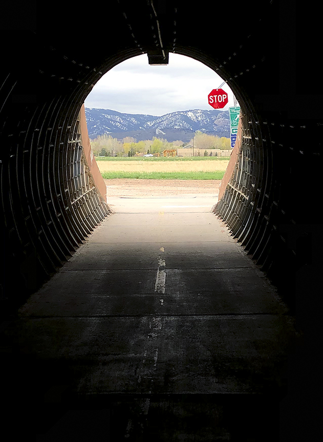
Stop
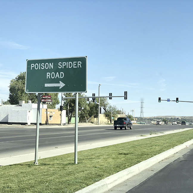
Poison Spider Road, Casper
Farther west of Casper, in the vicinity of Powder River, Wyoming, I passed a couple of antelope virtually on the road, so I pulled off at the same spot where a man driving a pickup-trailer also had pulled off. He wasn’t taking photos; he was adjusting something more securely on the trailer. As I pulled off, I noticed the Tumble Inn sign and pointed my camera there first, since the antelope had moved off some distance. The man walked over after a few moments and said, “That’s an iconic sign. Somebody should take it and preserve it.” I agreed that it would be a great shame if it were to be destroyed. He shared with me the information that the now-defunct (and derelict) Tumble Inn had at one time featured a topless dancer, and that men driving to and from this place, which is sited outside the regulatory reach of Casper (to the east) and Shoshoni (to the west), had occasionally met their demise thanks to drunk driving.
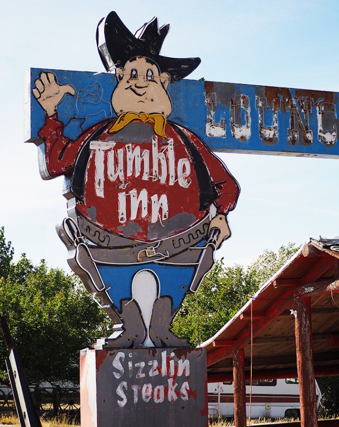
The defunct Tumble Inn, Powder River, Wyoming
The man reacted with dismay when he heard that I was headed to Yellowstone, which led to a conversation about the sheer numbers of park visitors and the crowded scenic drives in Colorado. “Everybody loves Colorado, but they’re going to love until they ruin it,” he said, and we speculated as to whether this had already happened. The man, who introduced himself as Gary and who was probably in his 60s, said that he was Arapaho, and that the traditional Arapaho territory was in the Loveland-Estes Park-Fort Collins area, where I now live. He himself had lived in Wyoming almost his whole life and owned a ranch near Riverton, on the Wind River Indian Reservation. His hair was tied back in a short, skinny ponytail that seemed unexpected given the rest of his haircut. He stuck out his hand when he introduced himself at the end of the conversation, saying “Maybe we’ll meet again down the road.” We didn’t, of course, but I would have liked talking to him more about his Wyoming.

Abandoned gas station, Powder River, Wyoming
At Shoshone U.S. Highway 20 turns north and eventually runs parallel to Wind River for several curving, beautiful miles. The traffic through Wind River Canyon is fast. I caught sight of a few signs marking geological time in the rocks exposed by the river. The first one I spotted said “Gros Ventre Formation — Cambrian.” The last one, “Chugwater Formation — Triassic,” indicated ochre-colored hills. In between I saw signs for Devonian- and Permian-age formations; there may have been others that I missed while zipping down the canyon with cars on my bumper, or while trying to find picture-taking sites. All told, the progression down the canyon covered more than 250 million years of geological time. I wished I had a miniature John McPhee, or a miniature geologist, on my shoulder to narrate details about the passage; it would be worth another trip to study the changes. Wikipedia says that the canyon was formed by tectonic shifts, not by river cutting.

The geology of Wyoming, or at least some of it, is the subject of McPhee’s excellent “Rising from the Plains,” one volume in his five-volume “Annals of the Former World.” McPhee, in consultation with geologist David Love of Laramie, reconstructs the geological events that led to Wyoming’s strange plethora of cross-cutting mountain ranges, many of which defy the dominant north-south trend of the Rockies. Despite having read this book three times, I can’t remember the particulars, but they can be summed up as “It’s complicated.” McPhee intercuts his story with tales of pioneer days, including fascinating excerpts from a journal kept by Love’s mother, who came to central Wyoming in 1905 as a frontier schoolteacher. I recommend both McPhee’s book and Annie Proulx’s “At Close Range: Wyoming Stories,” which jointly paint a picture of hardship and human extremes that parallel the extremes of the climate and the countryside here.

Igneous intrusions, Wind River Canyon


")


This afternoon I drove up to Soapstone Prairie Natural Area, located about 15 miles north of Fort Collins and about 10 miles south of the Wyoming border. The last several miles are on a very well graded dirt-and-pea-gravel road. I went to the north parking lot, where there was only one other car, and walked a short trail to a site that overlooks a former archaeological dig, now restored to prairie. This is some of what I saw. I’m still working on an identification for a couple of the plants. I’m also a bit puzzled by the rocks atop the fenceposts—are they decorative, or do they have some sort of significance I can’t read?
The sense of remoteness and the solitude were gratifying, very different from the isolation of being at home. It was a beautiful, unusually cool day for August and it was windy; my ears actually got cold. I was fine in a T-shirt but began thinking longingly of earmuffs; what a strange sight that combination would make! A hat or scarf would have done the trick. I want to return to this area soon with my Olympus and my binoculars.
Note: I have since learned that the purpose of the rocks is to divert water, thus preventing deterioration of the tops of the posts. Thanks to Michael Bliss for telling me this.


Of all the animals I saw at the Denver Zoo (and I didn’t get around the entire zoo), only the eland was bold enough to stand right at the front of its enclosure, getting a great deal of pleasure from rubbing its chin and neck against the scratching post and the enclosure cable. The okapi, with its gentle-looking eyes, beautiful brown coat, and modernist black-and-white legs, is one of my favorites. In-between shots, this one was munching grass. A check of Wikipedia reveals that okapis, which are endangered, are quite solitary, are most closely related to giraffes, and are “generally tranquil.” This female seemed pretty unperturbed at my presence.
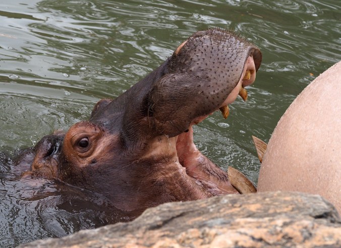
This hippopotamus wrestled her ball all around her little pond, trying to bite it (apparently). She’d go underwater for several seconds and then re-emerge to engage the ball again. As I think I mentioned a couple of posts ago, I have mixed feelings about zoos. I used to think they were important for conservation efforts and education, but I recently read a New Yorker article that rather convincingly refuted that argument. The obvious boredom of many of the animals, despite “enrichment” items such as balls and other toys, pains me. I don’t so much mind seeing fish or reptiles or amphibians in tanks (some photos of those later), but for mammals the Denver Zoo strikes me as a rather sad place.
I don’t actually know that this hippo is a female; I’m just guessing. Her/his teeth, especially those tusk-like lower canines, serve as a reminder that hippos are the most dangerous animal in sub-Saharan Africa (other than humans themselves) in terms of the number of people they kill. So I’ve read, anyway.

Never Summer Wilderness
View west from Trail Ridge Road to the Never Summer Wilderness.
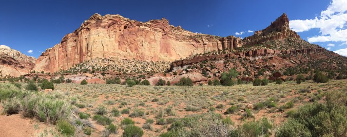
My blog is sagging under the weight of so much rock. For today, I’m posting just one Utah photograph, taken at Capitol Reef National Park. (It’s an iPhone panorama—I hadn’t experimented with this feature until now.) Aside from the highway that cuts across the north end of Capitol Reef, the park has only one paved road, which travels south just a few miles. At its terminus (shown here), a dirt road will take you about two miles east, through a narrow canyon called Capitol Gorge.
That road also leads me to a political note. The first time I visited Capitol Reef was in 1991. That visit was in May, before the full-fledged summer tourist season. My then-husband and I had the place to ourselves. We drove on a dirt road—probably Capitol Gorge Road—that was so rough I worried our little compact car would be shaken to pieces or get hung up on a rock and we’d be stranded for hours or days. Our vehicle was the only one on that curvy road, and we felt isolated indeed winding among the towering cliffs bordered by trees. It was beautiful, and it felt very remote.
This time around, at the same time in May, Capitol Reef was jammed with cars. The dirt road, it seemed, had been improved—still a little rough, but nothing like what I remembered; still beautiful, but heavily traveled.
The Trump Administration wants to declassify a number of national monuments, many of them long-established ones and a number of them in southern Utah, to open them to oil and gas drilling. This, I believe, would be a terrible decision. Reducing CO2 emissions demands that fossil fuels stay in the ground, and blighting this spectacular landscape with more industrial operations would desecrate it. (To many Native Americans, such as the Paiute, it is indeed sacred land.) Oil and gas drilling are not a sustainable activity. Tourism and recreation, in contrast, are sustainable sources of revenue for the citizens of Utah if properly managed (this assumes that one is most concerned about the people’s livelihood and not the profits of Big Energy).
But therein lies a paradox: Tourism on the public lands of southern Utah has become so popular that it must be controlled. Already Zion National Park runs on a shuttle system, as does part of Bryce Canyon National Park. Arches National Park, a section of which was closed this past May, badly needs to move to a shuttle system as well; it was overrun with cars in every parking lot and people thronged all the trails we visited.
I recently re-read the iconic book about southern Utah, Desert Solitaire, by Edward Abbey. Even back in the late 1950s, Abbey, who worked for a couple of seasons as a park ranger at Arches, deplored the development of “industrial tourism,” wherein people experience Utah’s great parks and monuments only by car, and the government builds more and more paved roads to accommodate them. Glad as I was to see these places again, I felt sorry to be limited to industrial tourism myself, physically unable to do much hiking and contributing to the congestion.
Abbey predicted that the road-building he saw happening in the 1960s would continue, and it has…up to a point. Happily, though, much of southern Utah remains unpaved and relatively unspoiled, especially the vast wilderness of Grand Staircase–Escalante—a long-established national monument that the Trump Administration wants to allow Big Energy to exploit. The sheer ruggedness of this wilderness of rock, sand, canyons (combined with a shamefully reduced budget for the National Park Service) has protected much of the land and left it alone for hikers, boaters, climbers, birders, and other nature lovers. Local tour and adventure companies do a big business here, one that is sustainable provided that the land is left as it is.
The crowds at Zion, Bryce, and Arches still experience beauty. But to experience solitude in Canyon Country, as it’s called, you must travel on dirt roads to the vast bottom of Canyonlands or the south end of Capitol Reef and then get out on foot, for even the strenuous trails at the better-known parks are popular. Or you must turn to the national monuments, such as Grand Canyon–Escalante, where no paved roads penetrate. The monuments, more than the parks, offer the experience of spell-binding wilderness.
Abbey speaks eloquently of people’s need for wild places. Even city people, he says, benefit by knowing that such places exist, untrammeled and remote, though they may never visit those places.
He was right. Abbey often expressed himself harshly, but Canyon Country itself is harsh. To my knowledge no writer has described its character so beautifully and so powerfully. Read Desert Solitaire. Then, if you’re of like mind, contact your state and national legislators to let them know you’re in Abbey’s camp—perhaps quite literally, if you’re an intrepid soul.

On a recent trip to Utah I took a boatload of bad photographs and only a handful of decent ones. This is my favorite: a small pine tree clinging to the rim of Bryce Canyon.
